GeoHealth Mapping GIS Training
for Monitoring and Evaluation or
Strategic Information Officers and Data Analysts for HIV

3. Working with Maps to Understand HIV Variation at Subnational Levels
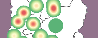
HIV researchers, policymakers, and funders increasingly emphasize data-driven responses to the HIV epidemic. By analyzing spatial data and mapping key indicators, policymakers and program planners can better identify geographic areas with high HIV prevalence, leading to more strategic resource allocation, prevention programming, and treatment coverage.
GIS allows users to combine various disconnected data sources—on population, disease, administrative boundaries, transportation routes, etc.—to see important relationships and patterns. Depending on data availability and quality, maps allow for examination of spatial variations in the HIV epidemic at various levels, including
- National
- Regional
- Provincial
- City
- Township
- Neighborhood
This section will introduce users to fundamental spatial analysis methods, all of which may be useful in exploring questions related to HIV programming. You might think of these methods as items in your spatial analysis "toolbox" that may be deployed in different ways, depending on your question of interest. Once you've mastered these skills, you will learn more about selecting appropriate methods for various questions in Section 5.